
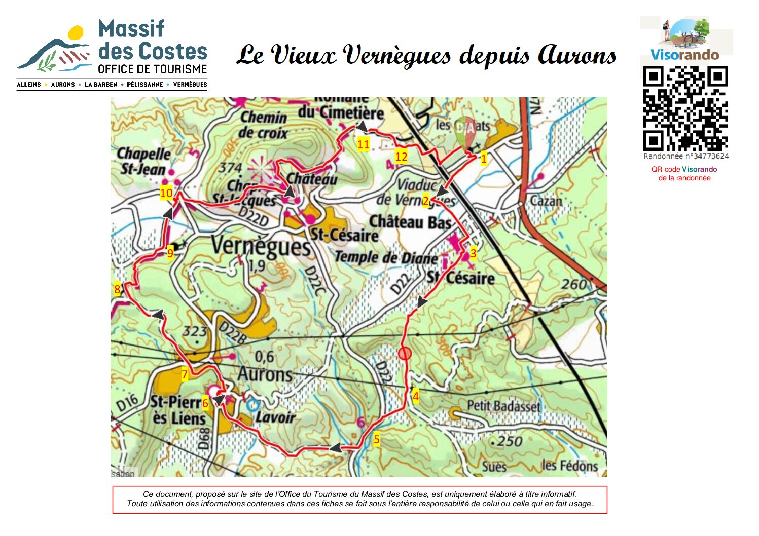
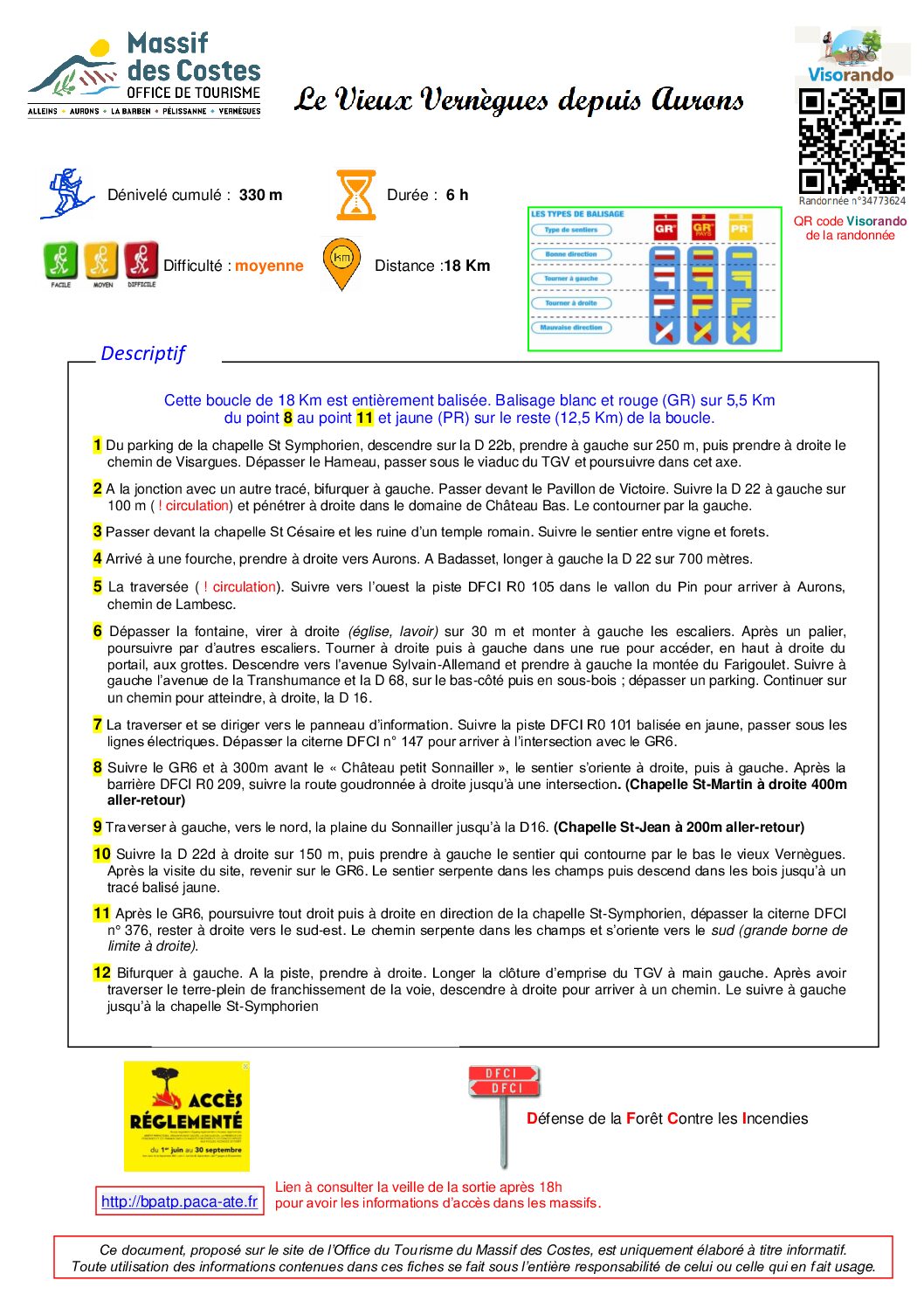
This loop of 18Km is entirely unmarked with white and red marks on 5,5Km.
- At the car park of Saint Symphorien Chapel, go down to the D22b, turn left and walk 250m, then, turn right on the path of Visargues. Go over the hamlet, pass the TGV viaduct, and continue this road.
- At the junction with another track, turn left. Pass in front of the Pavillon de Victoire. Follow the D22b on the left for 100m, attention there is traffic and enter the domain of Château Bas. Bypass it on the left.
- Pass in front of Saint Césaire Chapel and the ruins of the Romain temple. Follow the path between vine and forests.
- At the fork, turn right to Aurons. At Badasset, walk along the D22b for 700m.
- Cross the road. Follow west along the DFCI R0 105 valley until you reach Aurons, Lambesc’s path.
- Go past the fountain, turn right (church, wash house) for 30m, and climb the stairs on the left. After a landing, continue up more stairs. Turn right, then turn left into a street to reach the caves at the top right of the gate. Go down towards avenue Sylvain-Allemand and turn left onto montée du Farigoulet. Follow the Avenue de la Transhumance and the D68 to the left, along the roadside and then through the undergrowth; you will pass a car park. Continue along a track until you reach the D16 on the right.
- Cross the road and head for the information sign. Follow the R0 101 DFCI track marked in yellow, passing under the power lines. Go past DFCI tank no. 147 to reach the intersection with the GR6.
- Follow the GR6 and 300m before the ‘Château petit Sonnailler’, the path turns right, then left. After the R0 209 DFCI barrier, follow the tarmac road to the right as far as an intersection. (Chapelle St-Martin on the right, 400m round trip).
- Head north across the Sonnailler plain on the left to the D16. (Chapelle St Jean 200m round trip).
- Follow the D22d to the right for 150m, then turn left to take the path around the bottom of Vieux Vernègues. After visiting the site, return to the GR6. The path winds through the fields and then descends through the woods to a yellow signposted trail.
- After the GR6, go straight and turn left to the St Symphorien Chapel, pass over the tank DFCI no.376, stay right, heading south-west. The path winds through the fields and is oriented toward the south. There is a large boundary stone on the right.
- Turn left. Turn right at the track. Follow the TGV right-of-way fence on your left. After crossing the railway median, go right down the track to reach a path. Follow it to the left as far as the St-Symphorien chapel.
This document published on the Massif des Costes Tourist Office website, is for information purpose only.
Any use of the information contained in these sheets is under the sole responsibility of the person making use of it.


